Rhizome Aerial Limited
Last time updated: 2/10/23, 2:07 PM
About
Get an unparalleled perspective
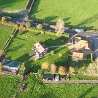
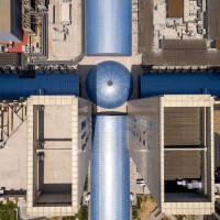
Rhizome is a UAV (drone) service provider covering all aspects of Drone works with a focus on the architecture and construction industry.
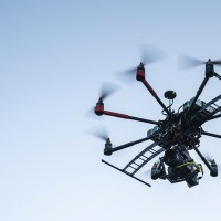
Fully qualified CAA drone Pilots.
Services include: aerial photography and videography, aerial surveying, orthomosaics, topological surveys, Measured building surveys, 3D laser surveys, roof and industrial inspections.
Images

Frequently Asked Questions
What are Rhizome Aerial Limited main services?
Aerial Photography, accurate visual representations, aerial mapping drone, aerial photography, aerial photography uav, aerial survey, aerial topographic survey, aerial videography, boundary survey, drone 3d mapping, drone photography, drone surveying, drone topo survey, industry survey, land survey services, measured building survey, orthomosaic, photomontage, property line survey, remote aerial photography, roof inspection, roof inspection services, site scan, topo survey, topographic site survey, topographic survey, topological survey, uav aerial mapping, uav aerial survey, uav mapping, uav survey, verified views, verified views planning, accurate visual representations, aerial mapping drone, aerial photography, aerial photography uav, aerial survey, aerial topographic survey, aerial videography, boundary survey, drone 3d mapping, drone photography, drone surveying, drone topo survey, industry survey, land survey services, measured building survey, orthomosaic, photomontage, property line survey, remote aerial photography, roof inspection, roof inspection services, site scan, topo survey, topographic site survey, topographic survey, topological survey, uav aerial mapping, uav aerial survey, uav mapping, uav survey, verified views, verified views planning.
Attention business owner!
Register your business now and enhance your global reach with iGlobal.
Copied to clipboard!